Comment accéder à l’Observatoire
COMMENT ACCEDER A L’OBSERVATOIRE ?
Localisation de l’Observatoire sur OpenStreeMap
Coordonnées géographiques de l’observatoire
Latitude : 47° 14’ 50,5" N (47.24736)
Longitude : 5° 59’ 22,5" E (5.98959)
accès par bus
L’accès a l’Observatoire se fait essentiellement par bus :
- La ligne 3 (arrêt CROUS Université) relie le campus à la gare et au centre-ville.
- Pour information, le tram 2 et les lignes 3, 5, 23 et 24 relient la gare au centre-ville. Le trajet se fait cependant facilement à pied (compter 10 minutes)
- plans du réseau de bus
- fiches horaires des lignes
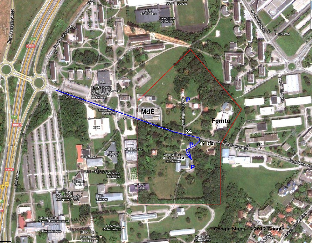
Pour le trajet final, voir le plan en bas de page
accès par la route
L’Observatoire est aussi accessible depuis l’autoroute A36 "La Comtoise" :
- Sortie 4 "Vesoul/Besançon - Saint Claude" dans le sens Dole-Mulhouse ou sortie 4 "Lausanne/Besançon-Centre/Besançon-Saint Claude" dans le sens Mulhouse-Dole ;
- Puis sur la rocade (N57) sortie 57 "Domaine universitaire" ;
Pour le trajet final, voir le plan en bas de page
accès par le train
L’accès à Besançon par le train se fait en vous arrêtant soit :
- arrêt TGV « Franche-Comté TGV » (agglomération de Besançon). Il vous faudra ensuite prendre soit la navette qui arrive à la gare « Besançon Viotte » (proche du centre-ville et des arrêts de bus), soit prendre un taxi.
- Arrêt « Besançon Viotte » (proximité centre-ville, arrêts de bus et hôtels),
puis suivre les indications accès par bus.
accès par l’avion
Les principaux aéroports permettant de rejoindre Besançon sont :
- Lyon
- Bâle
- Paris
- Genève
- certains vols intérieurs peuvent arriver aux aéroports de Dijon ou de Dôle, qui sont les plus proches de Besançon.
De là, suivre les indications accès par le train puis accès par le bus.
HOW TO REACH THE OBSERVATORY ?
coming by bus
Besançon Observatory can mainly be reached by bus :
- Line 3 (CROUS Université stop) connect the campus to the railway station and city centre.
- For your information, tramway 2 et lines 3, 5, 23 and 24 connect the railway station to city centre. Note that city centre is within walking distance from the station (less than 10 minutes).
- Bus-network map
- Bus and tramway schedule
For the final walk to the Observatory, look at the map at bottom of page
coming by road
Besançon Observatory can also be reached via tollway/highway A36 "La Comtoise" :
- Exit 4 "Vesoul/Besançon - Saint Claude" from Dole to Mulhouse or exit 4 " Lausanne/Besançon-Centre/Besançon-Saint Claude" from Mulhouse to Dole ;
- Next onto highway (N57) exit 57 "Domaine universitaire" ;
For the final strech to the Observatory, look at the map at bottom of page
coming by train
If coming to Besançon by train, go to :
- TGV station « Franche-Comté TGV » (agglomération de Besançon). You’ll have to take a shuttle to get to central station « Besançon Viotte » (next to city centre and the bus stops), or take a taxi.
- Central station « Besançon Viotte » ( next to city centre, bus stops and hotels),
then follow instructions from coming by bus.
coming by plane
The main airports to reach Besançon are :
- Lyon
- Basel
- Paris
- Geneva
- a few domestic flights arrive at Dijon or Dôle airports, which are the closest to Besançon.
From there, follow instructions from coming by train and then coming by bus.
MAP
Prendre la rocade N 1057 (E 23) et sortir à domaine universitaire. Suivre l’avenue de l’observatoire (impasse) et tourner à droite au 41 bis.